Uncovering one of the largest Mesolithic Sites in the UK
STONE AGE CRATHES
Aims
To find the full extent and intensity of the flint scatters at Crathes.
To
categorise
the
flints
for
indication
of
industry,
dating
(diagnostic
flints),
and
further
analysis
for
various
comparisons
1. Different parts of the site
2. With other sites
3. Flints found
in situ
4. With other collections from this site e.g J Grieve, J B Kenworthy
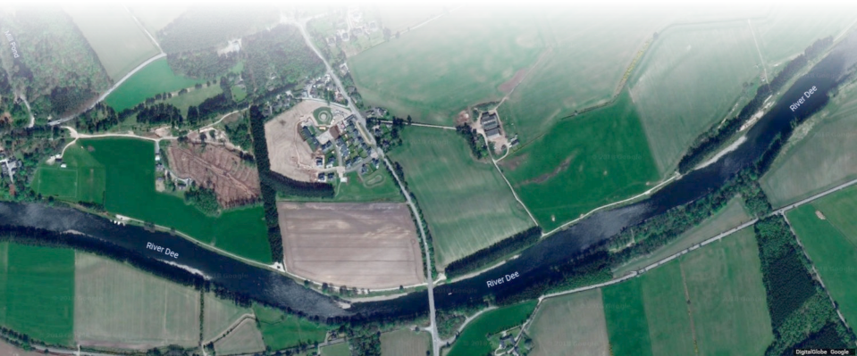
General Overview
In
the
1970s,
flint
scatters
along
the
River
Dee
were
recorded
by
Dr
John
Grieve,
leading
to
an
excavation
at
Nethermills
Farm,
Crathes
under
James
B
Kenworthy,
St
Andrews
University
over
four
seasons
from
1978-
1981. After meeting up with James almost 25 years later, this fieldwalking project began at Crathes in 2008.
The
project
(2008-2012)
over
five
contiguous
fields
along
the
North
bank
of
the
River
Dee
at
Crathes
was
conducted under the auspices of OFARS.
Fieldwalking
took
place
over
well-weathered
plough-soil.
Hand-held
GPSs
were
used
to
record
the
Easting
and
Northing
co-ordinates
of
each
find.
Walking
2m
apart
for
‘total
collection’
we
targeted
known
‘John
Grieve’
flint
scatter
sites
at
Crathes
(JBK
(pers
com),
Canmore,
Aberdeenshire
SMR),
together
with
adjacent
and
linking
areas.
Line
walking
about
5-10m
apart
over
remaining
areas
checked
out
the
possibility
of
other
scatters.
The
fields
were
labelled
from
East
to
West
as
Milton
Cottage
(MC),
and
Nethermills
(NM
1-4).
Unfortunately,
the
eastern
half
of
NM
4
was
never
finished
owing
to
lack
of
time
in
2009,
and
inaccessibility
in
following
years.
The
majority
of
the
lithics
were
found
on
two
river
terraces.
The
lower
terrace
of
Milton
Cottage
field
spread
into
NM
1,
2
and
3.
The
middle
terrace,
originating
below
the
steep
bank
of
the
upper
terrace
in
NM
1,
continued
into
NM
2,
3
and
4,
becoming
the
river
bank
in
NM
3,
with
the
’loss’
of
the
lower
terrace.
The
lithics
were
found
on
the
lower
terrace
of
the
MC
field,
and
mainly
on
the
middle
terrace
in
NM
1,
2,
3,
and
4,
with
very few on the lower terrace. In general, the lower terrace was more sandy and less pebbly.
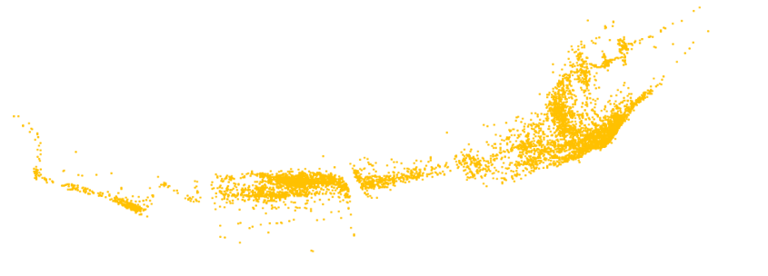
The lithics were catalogued and attributes recorded in Microsoft Excel.
Microsoft
Excel
‘Scatterchart’,
with
Eastings
on
the
x-axis,
and
Northings
on
the
y-axis,
showed
the
spread
of
the
scatters,
and
gave
some
indication
of
the
intensity.
In
the
more
intensive
areas
the
grid
reference
find-
points
represented
more
than
one
flint.
Charts
giving
the
exact
numbers
of
flints
per
10m
x
10m
squares
were compiled by counting the total number of flints at each relevant grid reference.
Although
the
scatter
was
continuous,
two
major
sites
were
identified
and
designated
Nethermills
West
(NMW),
centred
at
the
northern
edge
of
NM
1
spreading
into
NM2,
and
Nethermills
East
(NME)
centred
in
the SW corner of NM 4 (the location of the James Kenworthy excavation) and spreading over NM 3 and NM 4.
A
smaller,
less
intensive
site
(MC)
showed
up
in
Milton
Cottage
field,
and
two
smaller
intensive
areas
towards
the NW corner of NM 4 may represent two small sites, or be part of one larger one.
With
three
exceptions
the
assemblage
of
almost
10,000
pieces
is
of
flint.
The
predominant
colour
is
yellow-
orange-brown
(see
report
by
T
Ballin
2013
for
colour
descriptions,
page
8)
but
the
assemblage
from
Milton
Cottage field has a higher proportion of grey flint. Burnt flint was found throughout the site.
Much
of
the
material
is
damaged
or
broken,
but
all
stages
of
implement
manufacture
are
present.
Cores,
mostly single platform, and scrapers are also present.
The
major
part
of
the
assemblage
relates
to
the
Mesolithic
with
diagnostic
narrow
blade
microliths
(possibly
later)
whereas
broad
blade
microliths
may
represent
the
earlier
Mesolithic.
The
long
flake
and
blade
scars
on
the
platform
cores
and
the
flake/blade
ratio
(<5%
cortex)
suggest
that
blade
production
was
an
important
technological aim.
Leaf-shaped arrowheads, flaked knives, and a ground and polished knife indicate a Neolithic component.
Further
analysis
regarding
the
dimensions
and
other
technological
aspects
of
lithics
was
carried
out
using
Microsoft
Excel.
Single
platform
cores,
microliths
and
microburins
from
the
OFARS
fieldwalking
collection
agreed
quite
well
with
those
from
the
JBK
excavation
(T
Ballin
2013)
except
for
the
sizes
of
the
small
and
large broad blade triangles.
This
impressive
Mesolithic
site,
one
of
the
largest
in
the
UK,
extends
1.75km
along
the
north
bank
of
the
River Dee at Crathes, 250m northwards in NME, and may extend further east and west.
During
the
fieldwalking,
it
was
noticed
that
the
scatters
were
found
on
the
higher
areas
on
both
terraces,
possibly reflecting paleochannels or river braiding.
Addendum
In
NM
4,
the
Mesolithic
Deeside
Fieldwalking
Group
has
now
confirmed
a
more
intensive
area
towards
the
north
in
the
west
half
of
the
field
in
the
region
corresponding
to
the
two
concentrations
mentioned
above.
Flints
were
present
at
a
lower
intensity
in
the
eastern
part
of
the
field,
and
some
were
found
in
NM
5,
but
at
an even lower intensity.
The
terraces
have
now
been
identified,
but
for
the
sake
of
simplicity,
I
am
still
referring
to
them
as
lower,
middle and upper as we did during the fieldwalking.
THE PROJECT
References for the General Overview page
Torben Ballin (2013) Nethermills Farm, Banchory, Aberdeenshire. The Lithic Assemblage. 46 pages.
For publications relating to this project, see
Publications
page
.


